Why Blue-Green Corridors Matter for Climate-Resilient Cities
As cities confront rising temperatures, heavier rainfall and mounting flood risks, urban planners are increasingly turning to blue-green corridors as strategic tools for climate resilience. These integrated networks of waterways, wetlands, parks and vegetated streetscapes are designed to manage stormwater, enhance biodiversity and improve quality of life in dense urban environments.
Unlike traditional grey infrastructure — pipes, culverts and concrete channels — blue-green corridors leverage natural processes to store, filter and slowly release water. They reconnect rivers, canals and streams with surrounding green spaces, creating multifunctional corridors that support both ecological and human needs. For cities attempting to adapt to climate change while meeting housing and mobility demands, these hybrid, nature-based systems are gaining traction as a cost-effective and visible response.
From Grey to Blue-Green Infrastructure
Throughout the 20th century, many cities channelled rivers, covered streams and hardened shorelines, prioritizing flood defense and land reclamation over ecological health. The result has been fragmented ecosystems, higher runoff volumes and increased vulnerability to extreme rainfall events. Impervious surfaces — roads, parking lots, rooftops — now dominate urban landscapes, leaving little room for water to infiltrate naturally.
Blue-green infrastructure reframes water not as a threat to be contained, but as a resource to be integrated into urban design. By combining “blue” elements (rivers, canals, ponds, wetlands, retention basins) with “green” elements (parks, urban forests, bioswales, green roofs), cities can create networks that:
- Absorb and store stormwater during heavy rain
- Reduce peak flows and pressure on drainage systems
- Mitigate urban heat islands through evapotranspiration
- Support biodiversity and ecological connectivity
- Provide recreational and active mobility routes
Blue-green corridors are the backbone of this approach. They stitch together isolated pockets of green and blue space into continuous, functional systems that follow natural topography, existing waterways or former industrial corridors.
Key Components of Blue-Green Corridors
Successful blue-green corridors typically integrate multiple types of infrastructure, each performing a specific role within a broader hydrological and ecological network.
Core components include:
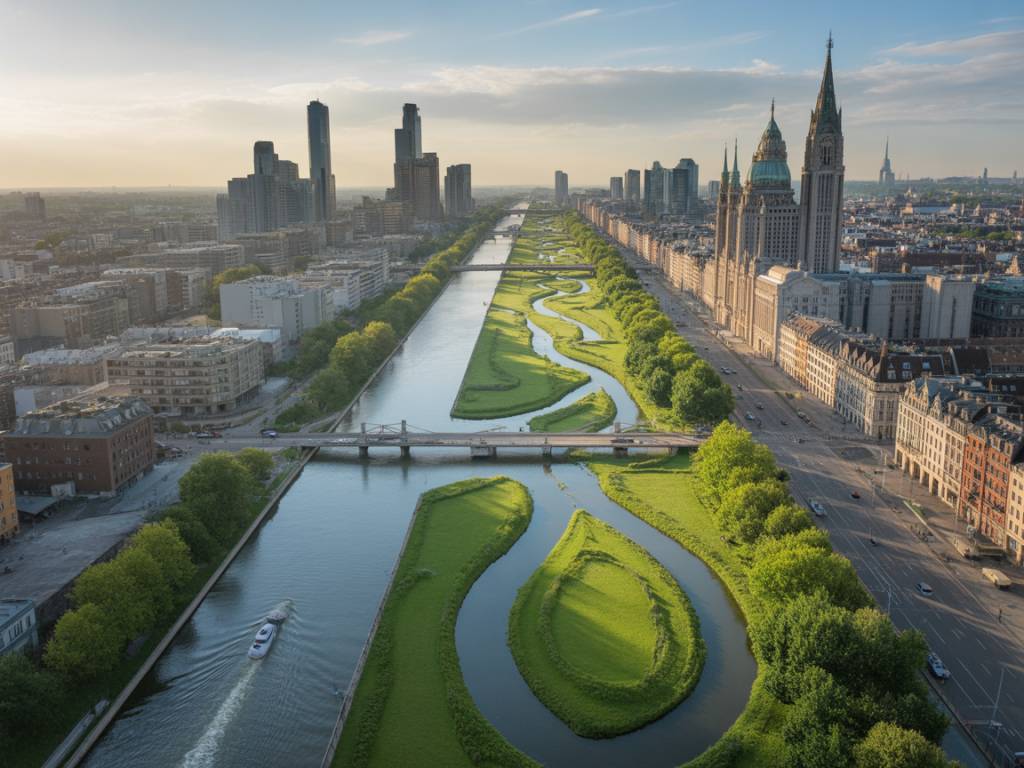
- Restored rivers and streams – Daylighting buried waterways, softening riverbanks and reintroducing meanders to slow flow and create habitat.
- Floodplains and retention areas – Designated parks, sports fields or urban wetlands that can safely flood during peak events, protecting surrounding streets and buildings.
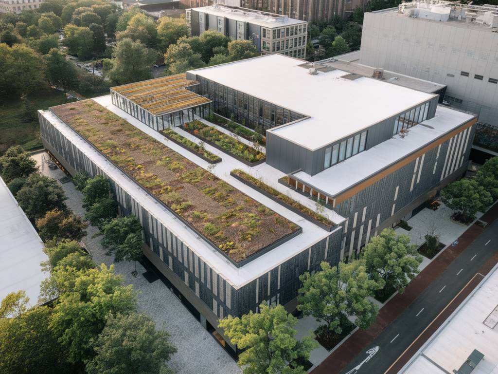
- Bioswales and rain gardens – Linear vegetated channels along streets and paths that capture runoff, filter pollutants and encourage infiltration.
- Permeable surfaces – Porous pavements in sidewalks, plazas and parking areas that reduce runoff volume by allowing water to soak into the ground.
- Urban wetlands and ponds – Engineered or restored water bodies that store excess water, improve water quality and provide microhabitats for wildlife.
- Greenways and linear parks – Continuous pedestrian and cycling routes that follow waterways or drainage axes, integrating shade, vegetation and water features.
When these elements are coordinated across neighborhoods and watersheds, they transform drainage systems into visible public assets rather than hidden technical infrastructure.
Climate Adaptation Benefits
The primary appeal of blue-green corridors lies in their direct contribution to urban climate resilience. They address several intertwined challenges associated with global warming and rapid urbanization.
Flood risk reduction. By retaining water in the landscape and slowing runoff, blue-green corridors help flatten flood peaks and reduce pressure on conventional drainage networks. During extreme rainfall, sports fields, parks and urban wetlands designed as temporary detention areas can store significant volumes of water, protecting critical infrastructure and residential districts downstream.
Heat island mitigation. Trees, vegetation and open water surfaces lower local air temperatures through shading and evapotranspiration. Continuous corridors can create cooler microclimates along active mobility routes and in dense neighborhoods lacking traditional parks. In heat-vulnerable districts, access to these cooler spaces becomes a public health measure as much as an urban design feature.
Water quality improvement. Natural filtration through soils and wetland vegetation can remove nutrients, heavy metals and sediments from stormwater before it enters rivers or groundwater. This reduces the impact of combined sewer overflows and improves the ecological status of urban waterways.
Biodiversity and ecological connectivity. Blue-green corridors act as migration routes and habitat patches for birds, insects, amphibians and small mammals. In fragmented metropolitan regions, they provide rare opportunities for native species to move, feed and reproduce, supporting more robust urban ecosystems.
Social, Economic and Urban Design Impacts
Beyond hydrological performance, blue-green corridors reshape the everyday experience of the city and can generate measurable economic benefits.
Public health and well-being. Access to water and greenery is strongly associated with reduced stress, increased physical activity and improved mental health. Corridors that combine walking and cycling paths with shaded rest areas and views over waterways support active lifestyles and create new social spaces.
Real estate and local economies. Proximity to well-designed blue-green infrastructure often increases property values and strengthens the attractiveness of nearby districts for residents and businesses. This can support local retail, hospitality and tourism sectors, particularly when corridors connect cultural sites, waterfronts and historic neighborhoods.
Place-making and identity. Reinvented canals, rivers and waterfronts can become signature elements of a city’s brand. Industrial waterways that once served logistics can be reimagined as recreational spines, anchoring new mixed-use developments while retaining traces of local heritage.
Equity and accessibility. When planned consciously, blue-green corridors can connect underserved neighborhoods to city centers and waterfronts, improving access to public space and sustainable mobility options. However, they can also trigger environmental gentrification, making careful policy design essential to ensure benefits are shared.
International Case Studies and Practices
Across regions, cities are experimenting with different typologies of blue-green corridors, adapted to their hydrological context, governance systems and land availability.
In Northern European cities, integrated water-sensitive planning has led to the creation of green-blue networks that manage frequent rainfall and protect low-lying districts. Projects often combine decentralized stormwater management at building scale (green roofs, rainwater harvesting) with district-level corridors that channel excess water to retention basins and wetlands.
In rapidly growing Asian metropolises, rising flood risks and land scarcity have encouraged the transformation of former industrial canals and railway lines into linear parks and water plazas. These multifunctional spaces serve as daily recreational assets and emergency buffers during monsoon events.
North American and Australian cities, faced with aging drainage infrastructure and high retrofit costs, are promoting nature-based solutions as cost-effective alternatives. Municipalities are experimenting with distributed networks of bioswales, rain gardens and daylighted streams that eventually feed into larger blue-green corridors along riverbanks and coastal edges.
Design Principles for Effective Blue-Green Corridors
Implementing blue-green corridors in existing urban fabrics involves more than adding isolated green or water features. Several design principles consistently emerge from successful projects:
- Catchment-scale thinking – Designing at the watershed level, understanding how water moves across multiple neighborhoods and jurisdictions, and aligning local interventions with broader hydrological flows.
- Multifunctionality – Ensuring each element delivers multiple benefits: flood storage combined with recreation, habitat creation combined with active mobility, or water purification combined with public space.
- Flexibility and adaptability – Allowing landscapes to change over time as climate projections evolve, incorporating modular designs that can be expanded or retrofitted.
- Integration with transport networks – Aligning corridors with public transit, cycling infrastructure and pedestrian routes to encourage low-carbon mobility and daily use.
- Community participation – Involving local residents, businesses and stakeholders throughout planning and implementation to build ownership, address safety concerns and align with local needs.
Governance, Financing and Implementation Challenges
Despite their advantages, blue-green corridors often face institutional and financial obstacles. Traditional governance structures separate responsibilities for water management, transport, parks and real estate, making integrated planning complex.
Key challenges include:
- Fragmented responsibilities – Multiple agencies and utility providers may control different segments of a corridor, complicating maintenance and long-term management.
- Budget silos – Investments in flood protection, public health, biodiversity and mobility are often funded from separate sources, making it difficult to account for cross-sectoral benefits in a single project budget.
- Land availability and competing uses – In dense urban cores, securing continuous corridors may require land acquisition, negotiation with private owners or reprogramming of underused infrastructure such as rail sidings and brownfields.
- Maintenance commitments – Vegetated systems and open waterways demand regular care. Without stable funding and clear responsibilities, performance and public perception can deteriorate.
In response, some cities are experimenting with innovative financing models, including stormwater fees, green bonds and public–private partnerships that link real estate value capture to blue-green infrastructure investments. Others are updating zoning codes and building regulations to encourage on-site water retention and green roofs that connect to wider corridors.
Integrating Blue-Green Corridors into Future Urban Development
As climate adaptation moves up the urban policy agenda, integrating blue-green corridors into master plans, zoning documents and infrastructure strategies is becoming a priority. For new development areas, this means reserving space for water and ecology from the outset, rather than retrofitting after problems emerge.
In existing city districts, opportunities often lie in:
- Reconfiguring oversized roadways into complete streets with bioswales and permeable surfaces
- Transforming obsolete industrial canals and rail corridors into linear parks and wetland chains
- Repurposing underused parking lots and vacant lots as stormwater gardens and mini-wetlands
- Connecting isolated parks and ponds through green streets, tree-lined avenues and restored stream segments
By treating water as a structuring element of urban design, rather than a constraint, cities can create networks that are at once technical infrastructure, ecological systems and social spaces. Blue-green corridors exemplify this integrated approach, offering a tangible, visible and adaptable pathway toward climate-resilient city design.